
Wild Weather in 2012: Yorkshire & Lincolnshire
Paul Hudson reviews a year of record-breaking weather across the region, learns how the extremes have affected communities and examines the future impact of such weather.
Paul Hudson looks back on a year of record-breaking weather across Yorkshire and Lincolnshire. He finds out how the extremes have affected communities and looks at what impact the weather might have in the future. Meanwhile, Keeley Donovan meets the people who've tried to battle through the weather to maintain normal life.
Last on
Weather In Yorkshire & Lincs 2012
The lowest temperature of 2012 (up to October 2012) for the UK was minus 15.6C at Holbeach, Lincolnshire on 11 February. This was associated with high pressure across much of Europe bringing easterly winds. Temperatures fell widely to minus 10C to minus 15C across Lincolnshire, although it was somewhat milder further north.
��
Much of north and east England recorded some lying snow between 5-12 February. On 5th, snow depths were 10-15cm across parts of Lincolnshire, elsewhere typically 5cm, but more across higher ground.
��
There were further snowfalls across the Pennines in early April, causing some disruption to roads and power supplies.
��
On 23 February the temperature at Holbeach reached 17.7C, a difference of 33.3C in only 12 days. It is very unusual for a 30C temperature difference within a month, particularly at a coastal location.
��
Both late March and late May saw unusual warmth across the north and east of England. On 28 May the temperature exceeded 26C in parts of Lincolnshire and Yorkshire.
��
On 28 June, parts of Lincolnshire were affected by intense thunderstorms. These were associated with hot, humid air from a 'Spanish plume' ahead of frontal systems pushing in from the west.
��
The warmest day of the year was 18 August - the temperature reached 29.8C at Skegness.
��
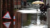
Parts of north and east England were badly affected by flooding from heavy rainfall associated with an area of low pressure from 24-26 September. A broad swathe of the North York Moors and North Pennines recorded over 150% of the monthly average rainfall during this three day period.
��
In January, rainfall was only 2/3 of average, and less than half in February and March. The period April 2010 to March 2012 saw well below average rainfall across much of north and east England.
��
By contrast, both April to June saw well over twice the average and the period April to July 2012 was the wettest April to July in the last 100 years by a margin equivalent to an extra months’ rainfall.
��
Source: Met Office, National Climate Information Centre, October 2012.
��
Figures are for January-October 2012 and cover Yorkshire, Lincolnshire and North East England
��The science behind Britain's wild weather

��ѿ��ý weatherman Nick Miller looks at the science behind what happened to Britain's weather in 2012.
��
He explains meteorologists' latest theories about why the weather in 2012 was so different from normal.
��
Nick Miller meets the Met Office's Adam Scaife and meteorologist Len Shaffrey to find out why the jet stream's unusual behaviour had such an impact on the UK's weather in 2012.
��
on the ��ѿ��ý News website.
Broadcast
 Sun 30 Dec 2012 17:30��ѿ��ý One Yorks & Lincs & Yorkshire only